Caves and shafts in Alt Urgell
Alt Urgell, with the northern slope of the Cadí and other Pyrenean ranges, offers high-mountain karst terrain where the cataloged caves and potholes tend to reflect harsher relief than in the pre-coastal counties: significant elevation changes, longer approaches, and exploration historically more limited by the Pyrenean orography itself.
177 cavitats (106 coves i 71 avencs) in Alt Urgell have been catalogued, mainly in les Valls d'Aguilar, Coll de Nargó and Josa i Tuixén. Font Bordonera, amb 955 m de recorregut.
The surveyed length of the caves with this data ranges from 3 to 955 metres. The depth ranges from 1 to 137 metres. 5 different rock types are recorded here. You can check the full entry for location, access and, where available, photographs and survey maps. The whole set of caves on this page can also be downloaded as CSV or JSON.
Alt Urgell has an area of 1447 km², located mostly in el Prepirineu. This means an approximate density of 12.2 catalogued caves per 100 km².
Municipalities
Rock Types
- Font BordoneraImportant surgència de 955 metres de recorregut a Coll de Nargó.
- Font d'AndanaCova de 679 metres de recorregut i 137 metres de desnivell a La Vansa i Fórnols
- Avenc de la Cabana d'en GarrabaAvenc de 62 metres de fondària a Pont de Bar.
- Forat de les Encantades del Pont d'EspiaInteressant cova de 312 m. de recorregut, engolida temporalment pel pantà d'Oliana.
- Cova de MontanerCova de 232 metres amb dues boques a Fígols i Alinyà.
- Cova de les EncantadesCova de 228 m. de recorregut a Cava (Alt Urgell), i a prop de Toloriu.
- Avenc del CataplanellAvenc de 63 metres de fondària a Coll de Nargó, (Boumort).
- Bòfia dels PratsAvenc de 36 metres de fondària a l'Obaga Negra (Coll de Nargó)
- Coves de la QueraConjunt de dues coves que sumen un recorregut de gairebé 200 m. a l'Alt Urgell.
- Grallera Gran del BoixederAvenc de 81 m. de fondària a la Serra del Cadí
- Cova de l'OrminiCova de 160 metres de recorregut a la serra de Sant Joan, Coll de Nargó.
- Coves de l'Escala i NS-19Cova de 144 metres de recorregut i 36 de desnivell a Les Valls d'Aguilar
- Cova de la BarraCova de 163 metres de recorregut a Les Valls d'Aguilar
- Cova de CarradonCova de 156 metres de recorregut a Alàs i Cerc (Alt Segre).
- Baborell de MontsecAvenc de 18 metres de desnivell prop de coll d'Arnat (la Vansa i Fórnols)
- Avenc de la Roca del CorbAvenc de 54 m. de fondària a Peramola (Alt Urgell)
- Forat Negre de BóixolsCova de 104 metres de recorregut a la serra de Carreu (Coll de Nargó).
- Forat Negre de la Roca de Set ComellesCova de 100 m. de recorregut, de gran interès arqueològic, a la serra de Sant Joan (Boumort).
- Avenc dels TronsAvenc de 41 metres de fondària a Coll de Nargó.
- Bòfia del Tossal del MorroAvenc de 53 m. de fondària a Cabó,(Boumort)
- Grallera del Coll de l'OllaAvenc de 44 metres de fondària a La Vansa i Fórnols
- Grallera Gran de CornellanaAvenc de 42 m. de fondària al Cadí (La Vansa i Fórnols)
- Forat Petit de Prat SobiràCavitat inèdita de 14 m de fondària a Coll de Nargó (Boumort)
- Forat Gran de Prat SobiràCavitat inèdita de 28 m de fondària a Coll de Nargó (Boumort)
- Forats de la NeuConjunt d'esquerdes de 37 metres de fondària a Cabó.
- Esquerdot de MontanerEsquerda de 79 metres de recorregut a Fígols i Alinyà
- Avenc de CerneresAvenc de 40 metres de fondària a Josa de Cadí.
- Avenc de Pic d'EspiesTravessia de 37 metres de desnivell, a Montanissell (Coll de Nargó)
- Pou de les GrallesAvenc de 35 metres de fondària a Les Valls d'Aguilar
- Espluga de les Caixes de FenolletInteressant cova penjada, d'interès històric, a Montanissell
- Avenc del CircuitAvenc de 31 metres de fondària a La Vansa i Fórnols
- Avenc del Torrent NegreAvenc de 31 metres de fondària al riu Rialb (Coll de Nargó).
- Avenc de la GinebraAvenc de 30 metres de fondària al NO dels Prats de Carreu,(Coll de Nargó).
- Cova de Boli ErminiCova de 65 metres de recorregut a Les Valls d'Aguilar
- Cova de Santa FeEspectacular cova que travessa part del cingle de la Muntanya de Santa Fe (Coll de Nargó-Organyà)
- Avenc dels Rocs de l'EsteveAvenc de 31 metres de fondària al NO dels Prats de Carreu,(Coll de Nargó).
- Avenc del Coll de la CreuAvenc de 27 metres de fondària al municipi de Coll de Nargó.
- Avenc del PitarellAvenc de 23 metres de desnivell al municipi de Coll de Nargó.
- Avenc de la CoçaAvenc de 30 metres de fondària a Senyús (Cabó).
- Avenc T-7Avenc de 22 metres de fondària a Les Valls d'Aguilar
- Grallera Petita del BoixederPetit avenc de 26 m. de fondària a la Serra del Cadí
- Cova de SantufaCova de 50 m de recorregut al torrent de Fornàs (Aristot, el Pont de Bar)
- Balma de la Font del BegalotGran balma amb font, sota la Roca del Corb (Peramola).
- Forat de les Cases NovesCavitat de 18 metres de fondària a Fígols i Alinyà.
- Tuta de VimaAvenc de 28 metres de fondària a Cava (Alt Urgell)
- Avenc del VernúsPetit avenc de 18 metres de fondària a La Vansa i Fórnols.
- Grallera de Prat RodóAvenc de 22 m. de fondària a la zona de Port del Comte
- Avenc T-4Avenc de 21 metres de fondària a Les Valls d'Aguilar
- Cova Gran de CerneresCova de 53 metres de recorregut a Josa de Cadí.
- Pou de la SerretaAvenc de 23 metres de fondària a Montanissell (Coll de Nargó).
- Espluga de FenolletCova de 49 m de recorregut a la Serra de Sant Joan (Coll de Nargó)
- Forat de l'InfernAvenc de 16 metres de fondària a Les Valls d'Aguilar
- Forat de la Bruixa de la Canal BaridanaAvenc de 20 metres de fondària a la canal Baridana de Josa (Josa i Tuixén)
- Avenc de Roca SenyúsAvenc de 25 metres de fondària a la Roca de Senyús (Coll de Nargó)
- Font de BulíSurgència de 51 metres de recorregut a Coll de Nargó
- Forat de Coma CastellsAvenc de 20 metres de fondària al Boumort en el municipi de Cabó
- Sumider de TaúsAvenc de 19 metres a la serra de Prada, Les Valls d'Aguilar
- Forat de les MosquesPetita cova de 51 m. de recorregut al Boumort (Cabó).
- Avenc de CafernaAvenc de 24 metres de fondària a Fígols i Alinyà
- Pou del FrareCova de 42 metres de recorregut a Cabó, (Boumort).
- Forat Negre de MiravallCova de 59 metres de recorregut a Les Valls d'Aguilar
- Cova de la Dolina BufadoraCova de 49 metres de recorregut a Fígols i Alinyà
- Cova dels EsquerolsPetita cova en rampa de 44 m. de recorregut a Josa del Cadí
- Bòfia de la Matella de les PlanesAvenc de 22 m. de fondària a Cabó, (Boumort)
- Bòfia del PinarPetit avenc de 17 metres de fondària a La Vansa i Fórnols
- Espluga Nº3 dels LladresPetita cova de 35 metres de recorregut a Ribera d'Urgellet.
- Avenc MarquèsAvenc de 14 metres de fondària a Montant de Tost (Ribera d'Urgellet).
- Cova CA-6Cova de 42 metres de recorregut a Les Valls d'Aguilar
- Avenc del BotadorAvenc de 17 m. de fondària a la vora del poble de Gavarra (Coll de Nargó)
- Cova PalomeraCova de 42 metres de recorregut a Les Valls d'Aguilar
- Forat RosCova de 35 metres de recorregut a Montanissell (Coll de Nargó).
- Cova de CafernCova de 31 metres de recorregut a Fígols i Alinyà
- Avenc de Pedra ParetEsquerda de 13 m. de fondària a l'Alzina d'Alinyà (Alt Urgell)
- Avenc del Pla FornesaPetit avenc de 16 metres de fondària a Les Valls d'Aguilar
- Avenc Superior del Coll de la CreuAvenc de 20 metres de fondària al municipi de Coll de Nargó
- Cova Superior de la BarraCova de 28 metres de recorregut a Les Valls d'Aguilar
- Cova del Torrent dels CortilsPetita cova sota Prat Llong (Cadí)
- El TutCova de 40 metres de recorregut a Cerneres (Josa i Tuixén).
- Avenc de la JaçaPetit avenc al municipi de Fígols i Alinyà.
- Espluga del MoroCuriosa cavitat residual a Montanissell
- Canya de l'ÓssaCova de 34 metres de recorregut al riu Rialb (Coll de Nargó).
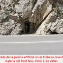
- Cova de la Galeria del Pont NouPetita cova de poc més de 30 m. de recorregut al congost de Tresponts (Fígols i Alinyà, Alt Urgell)
- Cova dels GegantsCova de 34 metres de recorregut a La Vansa i Fórnols
- Avenc del MortAvenc de 15 metres de fondària a Les Valls d'Aguilar
- Avencs Petits de CerneresCavitat de 10 m de fondària a la serra del Cadí
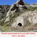
- Cova dels VoliacsPetita cova de 30 m. de recorregut al congost de Tresponts (Organyà, Alt Urgell)
- Avenc del Collet de la CreuAvenc de 15 metres de fondària Cabó,(Boumort).
- Grallera de l'Obac de MarcúsAvenc de 15 metres de fondària a la muntanya d'Alinyà. (Fígols i Alinyà).
- Bòfia de GuardiolaPetit avenc d'onze metres de fondària a Fígols i Alinyà
- Cova del CabanilAvenc de 9 metres de fondària a Tuixent
- Cova del SoldatCova de 27 metres de recorregut a Fórnols.
- Avenc de Sant MartíPetit avenc de 10 m de fondària a la vall del riu de Sallent (Coll de Nargó)
- Avenc de la Jaça de les VaquesPetit avenc de 13 metres de fondària a La Vansa i Fórnols
- Avenc B-2 de PlandelletCavitat de 12 metres de fondària a Cabó
- Cova de l'AiguaCova de 26 metres de recorregut a Fígols i Alinyà
- Bòfia de les OlivesPetit avenc de 12 m. de fondària a Cabó,(Boumort)
- Cova de la Casa SantaInteressant cova a la cara Nord de la Serra de Sant Joan, Cabó.
- Cova NS-21Cova de 16 metres de recorregut a Les Valls d'Aguilar
- Avenc T-8Petit avenc de 9 metres a la serra de Prada, Les Valls d'Aguilar
- Cova NS-3Cova de 17 metres de recorregut a Les Valls d'Aguilar
- Cova del PontPetita cova de 19 metres de recorregut a Les Valls d'Aguilar
- Avenc d'en BarcelóPetit avenc de 10 m. de fondària a la zona de Gavarra (Coll de Nargó)
- Forat del NadalPetit avenc de 10 m. de fondària a Cabó, (Serra de Prada)
- Cova de la Font de MiravallCova de 22 metres de recorregut a Les Valls d'Aguilar
- Forat de l'OliniGran balma de 22 metres de recorregut a Senyús (Cabó).
- La CatedralGran balma de 25 m. de fons a Peramola (Alt Urgell)
- Cova NS-1Cova de 15 metres de recorregut a Les Valls d'Aguilar
- Cova Petita de CerneresCova de 17 metres de recorregut a Josa de Cadí.
- Escletxa de Cal RoiAvenc de 10 metres de fondària al NO dels Prats de Carreu,(Coll de Nargó).
- Espluga de la Masia del CerveróGran balma murada que penetra uns 22 m., sota la Roca del Corb (Peramola)
- Avenc de la RataPetit avenc de 9 metres de fondària a La Vansa i Fórnols
- Espluga del SabaterCuriosa cova penjada a la Serra de Sant Joan i que serví d'amagatall
- Cova NS-2Cova de 14 metres de recorregut a Les Valls d'Aguilar
- Espluga Nº1 dels LladresPetita cova de 16 metres de recorregut a Ribera d'Urgellet.
- Espluga dels MaquisCuriosa cova penjada a la Serra de Sant Joan i que serví d'amagatall
- Avenc de la LlosaÍnfim avenc de 5'7 metres de fondària a Les Valls d'Aguilar
- Cova NS-14Cova de 14 metres de recorregut a Les Valls d'Aguilar
- Forat del Pla de CalamaPetita cavitat de 8 metres de desnivell al municipi de Coll de Nargó
- La Casa del CorbImportant balma obrada a Peramola (Alt Urgell).
- Espluga de la Font del CerveróGran balma amb font sota la Roca del Corb (Peramola)
- Cova T-13Cova de 10 metres a Les Valls d'Aguilar
- Cova del CastellotPetita cova de 12 metres de recorregut a Josa i Tuixén
- Cova del CorretgedorPetita cova en el Serrat del Ballador (Cabó).
- Cova TrencadaPetita cova de 15 m. de recorregut al S de Gavarra (Coll de Nargó)
- Grallera Petita de CornellanaPetit avenc de 7 m. de fondària al Cadí (La Vansa i Fórnols)
- Forat de la NeuPetit avenc de 6 metres de fondària a Josa de Cadí.
- Forat MicóPetita cova de 18 m. de recorregut vora Josa del Cadí
- Balma del Cigalot del CorbCuriosa concavitat foradada vora la Roca del Corb (Peramola)
- Cova dels Emboscats del Torrent NegrePetita cova al riu Rialb (Coll de Nargó)
- Cova Inferior de la BarraCova de 18 metres de recorregut a Les Valls d'Aguilar
- Cova dels PratsCova de 15 metres de recorregut a la Roca de Senyús (Coll de Nargó)
- Cova de la Casa VellaCova de 15 metres de recorregut a Montanissell (Coll de Nargó).
- Avenc T-3Petit avenc de 7 metres de fondària a Les Valls d'Aguilar
- Grallera de la SocarradaPetit avenc de 7 m. de fondària prop d'Alinyà (Alt Urgell)
- Cova N-1Petita cova de 10 metres de recorregut a Josa de Cadí.
- Feus del Riu de MolaSurgència temporal a la zona del riu Mola (Josa i Tuixén).
- Bauma del PontCova de 10 metres de recorregut al municipi de Josa i Tuixén.
- Avenc B-1 de PlandelletPetit avenc de 6 metres de desnivell a Cabó
- Cova NS-16Cova de 8 metres de recorregut a Les Valls d'Aguilar
- Cova Nº 1 del GrèvolCova de 9 metres de recorregut a Les Valls d'Aguilar
- Avenc N-3Petit avenc de 5 metres de fondària a Josa de Cadí.
- Espluga de CastellsGran Balma de 33x13 metres a Les Valls d'Aguilar
- Espluga de MiravallCova de 13 metres de recorregut a Les Valls d'Aguilar
- Cova dels Feixans de la TorreÌnfima cova d'11 metres de recorregut al municipi e Coll de Nargó.
- Avenc B-3 de PlandelletCavitat de 5 metres de fondària a Cabó
- CA-5-1Cova de 9 metres de recorregut a Les Valls d'Aguilar
- Baumes del MolíBaumes d'11 metres de fons a Josa de Cadí.
- Cova T-9.APetita cova d'onze metres a Les Valls d'Aguilar
- Grallera Petita de Prat RodóPetit avenc de 3 m. de fondària a la zona de Port del Comte
- Forat RodóPetita surgència de 7 metres de recorregut a Vilanova de Banat (Alàs i Cerc).
- Cova NS-9-BCova de 8 metres de recorregut a Les Valls d'Aguilar
- Balma del Roc del RumbauÀmplia balma amb pintures rupestres a Peramola.
- Espluga de la FeixaPetita cova d'uns 10 m de longitud vora el mas del Pitarell (Coll de Nargó)
- Espluga de la BercaBalma de 10 metres de fons a Fígols i Alinyà.
- Cova T-9.BPetita cova de 10 metres a Les Valls d'Aguilar
- Forat de les BoixederesÍnfim avenc de 3 metres de fondària a La Vansa i Fórnols.
- Cova Nº 2 del GrèvolCova de 6 metres de recorregut a Les Valls d'Aguilar
- Cova NS-23Cova de 8 metres de recorregut a Les Valls d'Aguilar
- Cova de PlugaoscuraCova de 9 metres de recorregut al municipi de Josa i Tuixén.
- Cova NS-9-ACova de 9 metres de recorregut a Les Valls d'Aguilar
- Cova del RoserPetita cova de 9 metres de recorregut a Les Valls d'Aguilar
- Avenc del Pla d'AubençPetit avenc de 4 metres de fondària al Pla d'Aubenç (Peramola)
- Cova N-4Ínfima cova de 6 metres de recorregut a Josa de Cadí.
- CA-5-2Cova de 6 metres de recorregut a Les Valls d'Aguilar
- Cova dels BlocsCoveta de tan sols 8 m. de recorregut al S del poble de Gavarra (Coll de Nargó)
- Cova T-9.CPetita cova de 8 metres a Les Valls d'Aguilar
- Cova N-2Ínfima cova de 5 metres de recorregut a Josa de Cadí.
- Espluga FumadaPetita balma al peu de cingle de la Serra de Sant Joan
- Cova del Pi GrosPetita cova de 7 metres de recorregut a Les Valls d'Aguilar
- Cova NS-10Cova de 4 metres de recorregut a Les Valls d'Aguilar
- Bòfia dels CómsMinúscul avenc de poc més de 2 m. de fondària a la Serra de Prada, (Cabó).
- Cova NS-8Cova de 5 metres de recorregut a Les Valls d'Aguilar
- Cova dels MorosPetita cova de 5 metres de recorregut a Vilanova de Banat (Alàs i Cerc).
- Forats de les Costes de la GuineuConjunt de petites cavitats al vessant S de la Serra de Sant Joan (Montanissell)
- Coveta Obrada de VimaÍnfima coveta vora el Mas de Vima (Cava, Alt Urgell)
- Forat de l'Orri d'AristotPetita cova al N d'Aristot
- Espluga Nº2 dels LladresÍnfima cova de 3,5 metres de recorregut a Ribera d'Urgellet.